You may have heard by now that I make maps. I’ve made dozens of them at this point, so I’ve learned a few things. I wanted to share a couple of basic ways to make your maps look more realistic and unique.
I use the word ‘rules,’ but these aren’t hard and fast, iron-cast laws – you can break them, especially if your world follows different laws of tectonics or physics to our own! In general, though, they will help create better looking maps.
1. Rivers Flow To The Sea
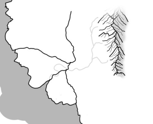
In general, rivers flow down in altitude – ending when they reach a large lake or the sea. Look for your mountains and hills; that’s where your rivers will tend to begin. Draw a meandering line down to the sea. Remember, rivers don’t usually split into two; instead, multiple rivers will merge. So this:
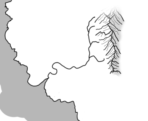
Is a much more likely river formation than this:
The major exception, of course, is on low altitude flood plains close to the sea, where you tend to get deltas.
Another river rule: the closer to the sea they get, the wider the river is – and the slower the current. This, along with the more gradually sloping terrain when compared to highland areas, means you’ll see more meanders – wriggles – closer to the mouth.
2. Mountains Form In Lines
In general, mountains form in straight lines – though you do occasionally get clusters of mountains, or places where two different lines of mountains intersect.
Mountains form when tectonic plates smash into each other; they are the areas of land disrupted by the movement of the plates below. They’re like ripples of distortion along the edges of the impact.
So instead of clustering your mountains, try to build them in lines, like this:

3. Cities Appear In Three Places
Of course, in the modern world, we have cities in all sorts of places – Brasilia, for instance, which was built specifically to be in the centre of Brazil. So if your cities are purpose-built, this advice might not apply to you.
Generally, though, cities that form organically appear in three different places: Bays, Rivers and Roads.
Cities and towns tend to appear where there’s a higher than average opportunity to access trade, while also being protected from the elements, from enemies, and where the general resources for life – food and water – are easily accessible.
- Bays are common city sites because they offer shelter from the elements for ships. A bay is a natural harbour, and in pre-modern settings, most trade took place via sea. Bays also provide ready access to fish, and water – especially if there’s a river nearby.
- Rivers are natural roads to the sea, so a city on a river is the next best thing for a seagoing merchant after a bay city. Rivers are usually freshwater, so the residents have a natural place to drink and wash, and they double as basic sewers, too. Often, fertile land flanks rivers – especially closer to the sea – so farming is easier there.
- Roads. It’s rare to find inland cities that don’t lie on a river or lake, because they often don’t have access to the resources needed to maintain such a large group of people living in one place. Where they do exist, they usually lie along well-used roads. There were ancient cities along the Silk Road which were maintained by traders passing through. These cities, though, tend to shrink and disappear if the trade dries up.
I hope these tips help you in your quest to create the perfect map!
